
Reading time: 5 minutes
The Headline
Confidence has increased that the global climate system is moving into an exceptionally strong El Niño event, with multiple independent forecasting centers now converging on a similar outlook.
At the same time, the Indian Ocean Dipole has moved decisively towards a positive phase, while the Southern Annular Mode has recently shifted negative but is forecast to return towards near-neutral conditions.
For Southern Africa, this combination represents a significant increase in seasonal climate risk. The regional rainfall response remains uncertain, however, and current water-storage conditions provide an important buffer.
Executive Summary
August marked a significant escalation in the developing El Niño event. Ocean temperatures across the central and eastern equatorial Pacific have continued to rise rapidly, while atmospheric circulation is now clearly coupled to the exceptionally warm ocean conditions.
Forecasts from major international centers increasingly indicate that this will become a very strong El Niño, with the event likely to persist into early 2027.
At the same time, the Indian Ocean Dipole has strengthened into a positive phase. Current Australian Bureau of Meteorology guidance gives a greater than 75% probability of a positive IOD through September–December, with the ensemble mean reaching approximately +0.8°C in November.
The Southern Annular Mode has provided a counter-signal. After a predominantly negative phase through much of July and early August, it is forecast to return towards near-neutral conditions during the coming weeks.
For the Garden Route, the immediate situation remains relatively favourable. Most major dams are effectively full, although Akkerloof remains considerably lower at 60.3%. However, rainfall across the Garden Route is currently approximately 14% below normal for August.
The result is a climate system in which the large-scale drivers are becoming increasingly aligned, while the region still retains a substantial water-storage buffer.
Climate Driver Assesment
| Driver | Current Status | Trend | Confidence |
|---|---|---|---|
| ENSO | 🔴 Very strong El Niño | ▲ Strengthening | High |
| Indian Ocean Dipole | 🔴 Positive phase established | ▲ Strengthening | High |
| Southern Annular Mode | 🟠 Trending neutral | ▶ Variable | Moderate |
| Overall Climate Signal | 🟠 Increasing alignment | ▲ Increasing | High |
What changed during August
1. El Niño has strengthened substantially
The most significant development during August has been the rapid strengthening of El Niño.
The latest observations show exceptionally warm sea-surface temperatures across the central and eastern equatorial Pacific, accompanied by strong positive upper-ocean heat content.
The atmospheric response is now clearly established, with enhanced convection over the central and eastern Pacific, suppressed convection over Indonesia and persistent westerly wind anomalies across the central equatorial Pacific.
This is important because it confirms that the event is not simply an unusually warm patch of ocean. The ocean and atmosphere are now strongly coupled.
Forecast guidance has also strengthened considerably.
The August ECMWF ensemble shows Niño 3.4 anomalies reaching exceptionally high levels during late 2026, with many ensemble members exceeding +4°C.
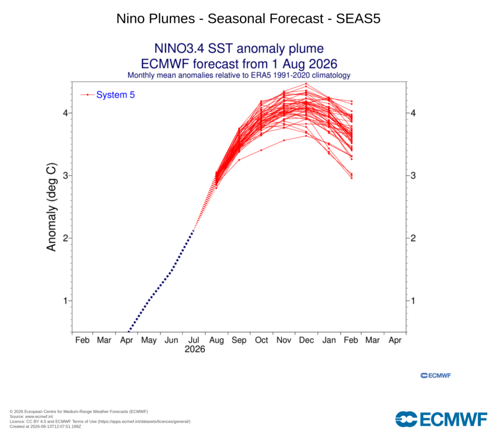
The WMO multi-model assessment similarly indicates a very strong event, with the ensemble mean Niño 3.4 anomaly reaching approximately +3.6°C during September–November. The precise magnitude remains uncertain, but the direction of travel is now considerably clearer.
2. The Indian Ocean is becoming increasingly important
The positive Indian Ocean Dipole signal has strengthened significantly since the July brief.
The latest Australian Bureau of Meteorology forecast shows the ensemble mean IOD index at approximately:
+0.5°C September
+0.6°C October
+0.8°C November
+0.7°C December
The probability of a positive IOD remains high through the remainder of 2026.
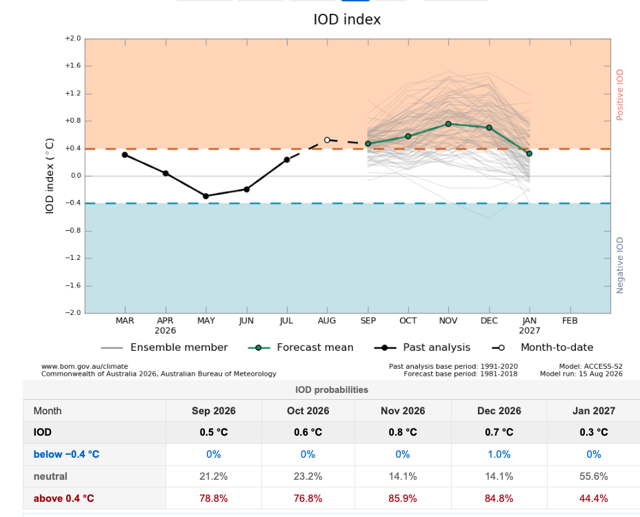
This is an important data point because the IOD can influence the atmospheric circulation affecting southern Africa and may reinforce some of the broader circulation changes associated with El Niño. The combination of a very strong El Niño and positive IOD therefore represents a more concerning configuration for Southern Africa than either signal considered in isolation.
However, the relationship is not deterministic. Regional rainfall remains dependent on the interaction of multiple atmospheric and oceanic processes.
3. Southern Hemisphere circulation remains a key uncertainty
The Southern Annular Mode has undergone a notable transition.

After spending much of July and early August in a negative phase, SAM briefly moved into positive territory before again trending back towards neutral conditions as you can see above.
The latest ACCESS-S2 forecast shows the ensemble mean returning towards values close to zero during late August and the first half of September.
This means that SAM is currently not providing a persistent strong signal in either direction.
For the Garden Route, this remains an important variable to monitor. The evolution of SAM can influence the frequency and positioning of Southern Hemisphere frontal systems and therefore modify the regional rainfall response to the tropical climate drivers.
The important point is that SAM can modify the regional outcome even when ENSO and the IOD are strongly established.
Southern Africa Outlook
For Southern Africa, the seasonal outlook should continue to be viewed as an evolving probability rather than a fixed forecast. The large-scale signal is increasingly clear: a very strong El Niño is developing alongside a positive IOD, with both expected to persist through much of the coming season.
The latest ECMWF and CCSR/IRI forecasts show elevated probabilities of below-normal rainfall across parts of southern Africa during the coming seasons, while temperatures are strongly favoured to remain above normal.
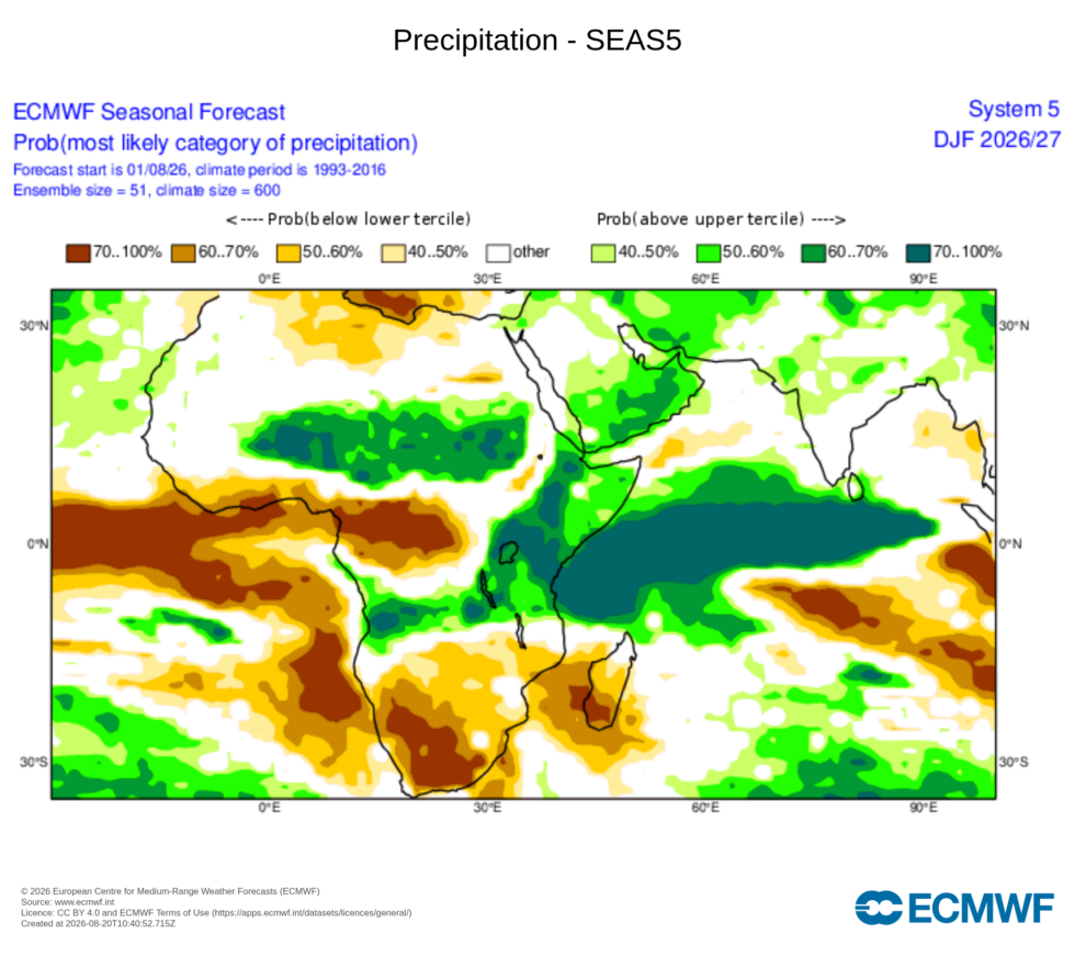
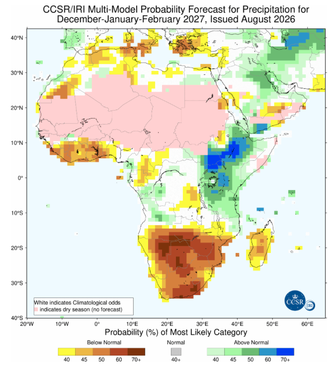
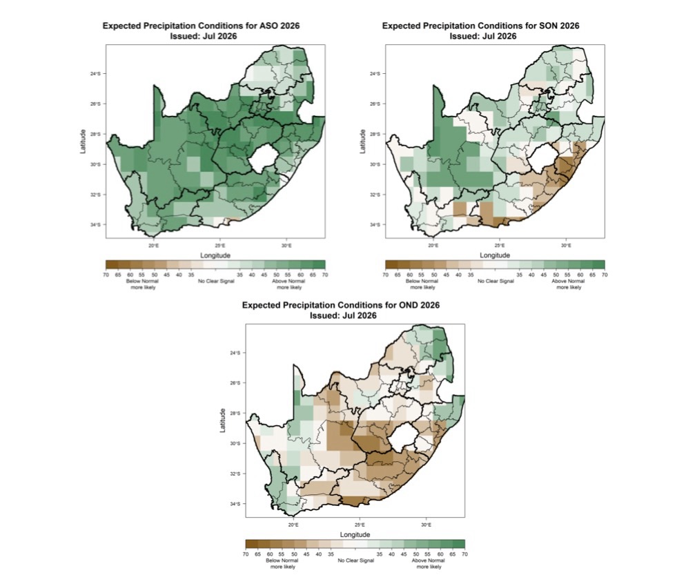
It is important to remember that these seasonal forecasts are not predicting how individual weather events will evolve. Also, a strong El Niño does not mean that every month will be dry, nor does it mean that every location within Southern Africa will experience the same rainfall response. This understanding is particularly important for the southern Cape, where rainfall is strongly influenced by the behaviour of individual frontal systems.
The South African Weather Service has already reported exceptionally low July rainfall across parts of the south-western Western Cape. Cape Town International Airport recorded only 14.4 mm during July, its lowest July rainfall since records began in 1958!
The Garden Route has also experienced below-normal rainfall, although with considerable variation between locations. The July figures indicate that the region experienced about 25% below normal rainfall and so far August is approximately at 14% below normal.
This obviously does not establish the emergence of a drought but It does provide an early indication that the rainfall is already becoming less favourable in parts of the region.
Garden Route Watch
The Garden Route enters the second half of 2026 from a relatively strong water-storage position.
The latest Garden Route District Municipality figures for 11–17 August show most major dams at or very close to full capacity.
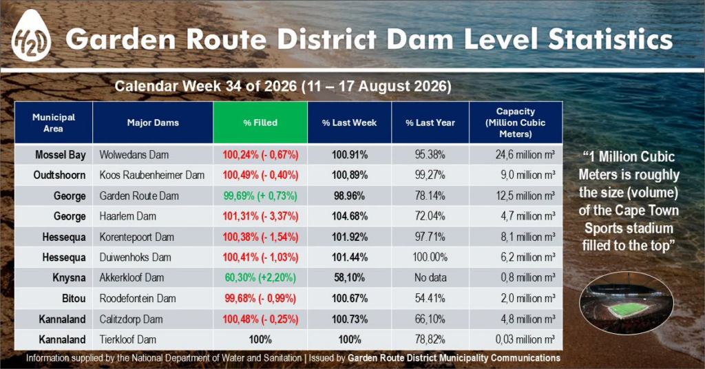
You will notice when looking at the above data, however, that for the first time since the extreme events of late May and early June the dams are showing a small decline. This highlights the concern around what happens to these buffers if the developing climate signal translates into persistently below-normal rainfall during spring and summer. High dam levels provide resilience, but they do not guarantee that the current levels will persist.
For water managers and communities, the current period therefore represents an opportunity to maintain preparedness while storage conditions remain favourable. The objective should be to avoid being caught unprepared if the increasingly unfavourable climate signal materialises.
Confidence Assessment
Confidence in the overall climate outlook has increased substantially since July. This assessment is based not on any single forecast, but on the convergence of multiple independent sources:
NOAA observations and outlooks,
ECMWF seasonal forecasts,
IRI multi-model guidance,
WMO global seasonal assessment,
ACCESS-S2 forecasts for the Southern Hemisphere,
South African Weather Service regional outlook,
Garden Route District Municipality water-storage data.
The most important change is the increasing agreement between observations and forecasts. The El Niño ocean signal is exceptionally strong. The atmosphere has coupled to the ocean and the positive IOD signal has strengthened.
Seasonal models are increasingly identifying warmer conditions and elevated probabilities of below-normal rainfall across parts of southern Africa.
At the same time, local rainfall and reservoir conditions demonstrate why regional outcomes cannot simply be inferred from the global climate signal.
Confidence in the large-scale climate direction is high. Confidence in the precise rainfall outcome for the Garden Route remains considerably lower.
Looking Ahead
Key indicators to watch during September include:
- Whether the positive Indian Ocean Dipole persists at the strength currently forecast.
- Whether the Southern Annular Mode remains near neutral or establishes a sustained phase.
- Whether below-normal rainfall continues across the southern Cape.
- Whether Garden Route dam levels begin declining materially as the region moves towards spring and summer.
- Whether independent seasonal forecasts continue to converge on a warmer and drier southern African pattern.
The most important question now is how the interaction between El Niño, the IOD and Southern Hemisphere circulation will translate into regional rainfall over the coming months.
This assessment is intended to support climate literacy, early warnings and informed decision-making. Seasonal forecasts describe probabilities, not certainties. Local outcomes can differ substantially from the large-scale climate signal.